
Even when boating close to shore, it can be difficult to relocate a favorite fishing or Scuba diving site, without a nearby marking buoy or some other point of orientation. Luckily, GPS and a good depth sounder has made it relatively easy to return to a hidden rock reef or a shipwreck of interest. But we can only imagine how challenging it was for the earliest mariners, as they sailed out-of-sight of land.
Some 4,000 years ago, the Phoenicians (formerly Syria, Lebanon and northern Israel) developed primitive charts and learned to orient themselves on the sun and stars to determine their direction. During the late 9th century, they created a primitive but useful device called Kamal. Orienting themselves on the North Star, they navigated north or south. The device was eventually adopted by Chinese mariners.
The Chinese are believed to have been the first to develop a compass. Using a fragment of lodestone, a naturally magnetic mineral, they suspended the material so that it could turn freely. It always pointed in the same direction. The mineral was later formed into a spoon that turned over a smooth surface; the handle pointed south.
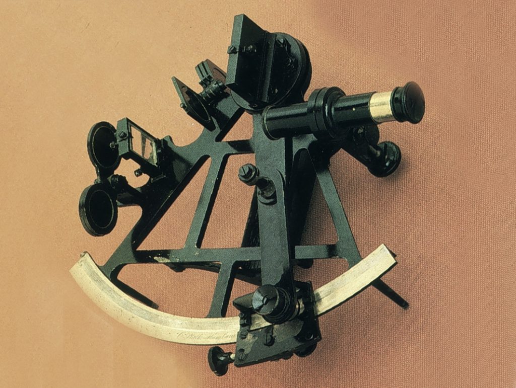
During the early 1700s, an English mathematician, John Hadley and an American, Thomas Godfrey, using the earlier work of Sir Isaac Newton, separately developed the first sextants.
The sextant is basically a telescope. Aiming the device toward the sun or North Star with the base lined with the horizon, a window with two sides comes into view; one of glass and the other mirrored. With the solar target positioned on the mirror side, the sextant’s knob it turned until the target lowers to the horizon into the window. Once that is accomplished, it is a matter of reading the angle at which the arm stopped on the device’s curved arc. The position is then calculated from there.
During the early days of World War ll, British bombers flew over German targets during daylight hours. However, as their unsustainable aircraft losses mounted, it became evident that nighttime runs were preferable. But, precision bombing at night was not possible. Thus, in 1940, British scientist Robert J. Dippy recommended the development of a targeting system bases on a grid. The proposed system was named Gee. In that same year, the U.S. Signal Corps called for a similar system with a minimum accuracy of 1,000 feet at a range of 200 miles. The U.S. Navy had also noted that convoys heading across the Atlantic, were relying entirely on celestial navigation. The weather however, was frequently so bad that the sky wasn’t visible during the entire crossing. Under those circumstances, the vessels sometimes lost sight of one another, leaving them more vulnerable to attack. Sponsored by the U.S. Navy, MIT scientists began work on a radio navigation system in 1940. It would become Loran A (long-range navigation). In mid-1942, Robert Dippy came to the U.S. to assist in the system’s development. At his insistence, the Gee and Loran receivers were made physically interchangeable, so that British and American aircraft could use one or the other by swapping units. The first bombing raid using the Gee system occurred on the night of March 8/9, 1942, over Essen, Germany.
During WWl, the British had developed a system to locate the source of enemy canon fire. They did so by using three separate listening posts from which they recoded the sound’s time of arrival. Called a hyperbolic system, Loran operated somewhat similarly. Its receiver aboard a ship or aircraft, picked up radio signals from one or more pairs of stations spaced hundreds of miles apart. The time difference between the transmitted signals determined their position.
In June 1942, the Nation’s first Loran A transmitters were installed at Montauk Point, New York and at Fenwick Island, Delaware. In the fall of that same year, additional stations were established on Canada’s east coast and other Atlantic sites. By 1943, Loran receivers had been installed in over 450 aircraft of the Coastal Command.
Loran A played a major role in the Pacific war. The ocean’s wide expanse was frequently far beyond the fuel range of World War ll aircraft. As out forces expanded across the Pacific, air fields were established on small islands and atolls. Loran A then provided accurate navigation to those air fields and air strikes. All of the B-29s were equipped with Loran receivers as was the Enola Gay, the first aircraft to drop an atomic bomb.
Typically, a Loran chain consisted of three or more stations that included a master and at least two secondary transmitters. Maned by U.S. Coast Guard personnel, the stations’ crews consisted of cooks, hospital corpsmen, damage controlmen and enginemen. Though they contributed a great deal to the war effort, Guardsmen stationed at Frederiksdal, Greenland, found their assignment difficult. Their experience was described in a log entry dated May 17, 1943. “Food propositions really getting disastrous. Coffee has been out for months, got enough cocoa for week, potatoes (dehydrated) are running out, powdered milk is getting low. Vienna sausage, bologna, ground pork sausage is our regular diet. Fresh meat has been out since the second week in March. Last vessel to come in here was COMANCHE on 26 February. Last mail, dropped by plane, 31 March. Great life, isn’t it?”
By the end of the Second World War, the value of navigation assisted by Loran had become evident not only for the military but also for the merchant marine. It was thus decided to expand the system. With the development of Loran C, which offered a great deal of greater accuracy, Loran A was phased out. Loran also became popular for civilian use. It continued to serve the Nation’s mariners until February 8, 2010 when it was replaced by GPS. The combined Russian American Loran Chayka signals and USCG transmission of Canadian Loran were terminated in August of that year.
GPS (Global Positioning System) had been initiated for use by the military. Its first satellite was launched in 1967. With the downing of a Korean airliner in 1983 by the USSR, it was decided to open its use to civilian air traffic so they could avoid straying over restricted foreign territory. Launched and operated by the U.S. Air Force, the system utilizes 32 satellites in orbit with 31 operational. Many of us are now dependent on GPS to locate a new address from our automobile. Its accuracy is also greatly appreciated by all mariners.
The Northeast Fisheries Science Center (NOAA Fisheries) provides an easy-to-use tool to convert Loran coordinates to Latitude / Longitude: https://fish.nefsc.noaa.gov/loranconv/latlonarea.shtml.