
In the midst of skyscrapers reaching toward the clouds, people dodging each other on crowded sidewalks, wall-to-wall traffic and packed subways, the 172-acre island, a half-mile from the tip of Manhattan, provides visitors with peace and tranquility from a busy city. Standing at the mouth of the East River, the island refuge is in view to the west of the Statue of Liberty and Ellis Island.
Native Americans, the Lenape, once occupied the island they called Paggamuck (=Nut Island), named after its lush growth of oak, chestnut and hickory trees. At that time, the island was apparently used as a seasonal fishing camp. During the 1980s through the 1990s, archaeological surveys discovered mussel, clams and oyster shells discarded by tribal members. Shellfish apparently had served to supplement their diets.
Searching for a Northwest Passage to China, Italian explorer Giovanni da Verrazzano entered New York Bay on April 17, 1524. He and his crew were the first Europeans to enter its waters. Writing to the King of France who had financed his voyage, Verrazzano remarked that when they approached the Native Americans on shore aboard their vessel’s small launch, tribal members “showed great delight at seeing us. They even offered us some of their food.” Before returning to France, Verrazzano continued his northward exploration to Narragansett Bay, Rhode Island, and then much farther north to Newfoundland. Henry Hudson was the next European explorer to enter New York waters (1609). He was followed by Adriaen Block in 1614.
In 1623, a Dutch ship arrived in New York Bay where its crew is believed to have established a small settlement on Nut Island (Noten Eylandt). Some 14 years later, the Dutch West Indian Company purchased the island from the Lenape tribe for “two ax heads, a string of beads and a handful of nails!”
The British captured New Amsterdam (New York City) and Nut Island in 1644. The island was later renamed “Governors Island.” With the onset of the American Revolutionary War, British military withdrew from the area and headed to Canada to regroup and rearm. To protect themselves from British warships, the Continental Army immediately began to erect an earthen works fortification on Governors Island’s highest elevation, arming it with four 32-pound guns and four 18-pound guns. It is believed that its site was the same as the current Fort Jay.
The Red Coats returned in late August 1776. Landing some 32,000 British and German troops on Long Island and Staten Island, the engagement, known as the Battle of Brooklyn, took the lives of about 1,000 American troops. General Washington however, was able to avoid capture of his remaining troops by boarding small boats and retreating across the East River to Manhattan. The 2,000 American troops on Governors Island also made a successful escape. The defenders had sunk so many of the enemy’s vessels that “tops of mast could be seen in the water and only rowboats could pass between them.” But by mid-October 1776, the British had gained complete control of New York City.
Marking the end of the Revolutionary War, the British evacuated New York in November, 1783. As part of an effort to guard east coast harbors, a system of American Coastal Fortifications was initiated.
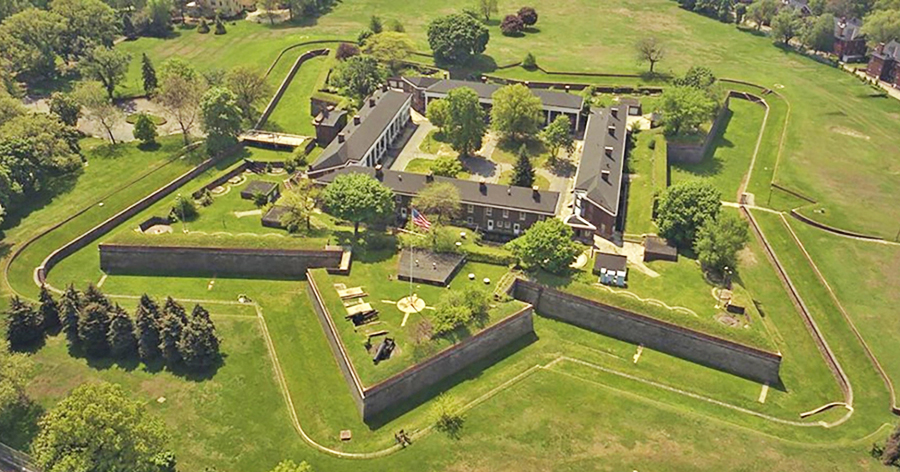
On Governors Island, Fort Jay which wad fallen into disrepair, was rebuilt. During about the same time, a circular fortification of 8-foot thick red sandstone (Castle Williams) was erected on the northwest point of the island. In 1812, the South Battery was built on the east side of the island, protecting the Buttermilk Channel between the island and Brooklyn.
Forts were also built on Liberty Island (Fort Wood), Ellis Island (Fort Gibson) and Castle Clinton at Manhattan’s Battery Park. By 1814, New York Harbor was said to have been protected by some 900 artillery pieces and 25,000 troops. During the War of 1812, British naval vessels completely avoided the harbor.
After the onset of the Civil War, Castle Williams served as a prisoner of war camp for Confederate enlisted men. About 1,000 were held at the fort in reportedly very cramped and unsanitary conditions. Fort Jay, also used as a POW camp, held Confederate officers in much more comfortable conditions. By the late 1870s, the island had become an important military establishment. Castle Williams continued to serve as a military prison until 1965 and in the following year, the Army turned over the island to the United States Coast Guard. The site then became the Coast Guard’s largest installation. It was the home for the Atlantic Area Command. They remained stationed there until 1996, marking the end of a military role for Governors Island.
In 1912, during the time that the had Army operated from the island, the physical size of the island was increased by some 103 acres. It was accomplished using 4,787,000 cubic yards of fill from the excavation of the Lexington Avenue Subway and dredge materials from the Hudson River.
In 1966, New York City’s Landmarks Preservation Commission designated 90 acres of the island as a local Historic District. Five years later, President Bill Clinton designated 22 acres of Governors Island as a National Monument, placing them under the management of the National Parks Service. The acreage included Fort Jay and Castle Williams and the area that surrounds them.
As you cruise down the East River and pass under the Brooklyn Bridge, sail slightly north of Governors Island. Fort Jay and Castle Williams will be view. However, better still, take the time to explore this fascinating treasure just off the tip of Manhattan. The island is open to visitors between May and September and weekends and holidays between 10 am to 7 pm. The island is vehicle free. It is open to picnicking, strolling and biking, along with guided tours of Fort Jay and Castle Williams.
Access to the island is via a less than 10-minute ride aboard a ferry, from the Battery Maritime Building at 10 South Street in Manhattan or from Brooklyn, at the Red Hook/Atlantic Basin. For more information, go to https://www.ferry.nyc/routes-and-schedules/.